The Armchair Treasure Hunt Club
|
| This article first appeared in the August 2002 (issue 63) newsletter. Newsletters are sent
quarterly to all current members.
© 2002 all rights reserved. Reproduction is prohibited. |
In the first part of my two-part navigation feature I covered some general concepts on navigation, focusing principally on use of the Ordnance Survey of Great Britain (OSGB) system. In this issue I'll take a look at a truly global navigation system and and some if the clever electronic devices that help us utilise it. Clive Weatherley has helped me illustrate the leisure possibilities for the system with an introduction to Geocaching - a kind of treasure hunting by numbers, if you will.
In the last issue I described in detail - in fact quite possibly more detail than you really needed - the concepts of Geodetic Datums and OSGB36. To recap, OSGB36 is a set of specifications that are used with Ordnance Survey maps. They are 'rules' that tell users how to specify, using a metric grid, any point in the UK - as crudely or as precisely as we like. Typically we find the two letter reference corresponding to the l00km x100km square we are in and then measure from the south east corner of that square, the distance across (easting) and up (northing) in metric units (kilometres). By using between l and, say, 5 digits for each measurement we can describe a point to l within 10km and l metre respectively.
All well and good - this system allows us to easily compute approximate distances between two points in the UK and find our way around OS maps with ease, but as we all know, the world isn't really a flat map. What works for the northern, small, thin landmasses of the UK would not work well for the huge wide expanse of the USA. Applying OSGB36 to the USA would create inaccurate distances, especially at the east and west edges. So when it comes to giving coordinates that can properly relate two arbitrary points on the globe, we need to use a Geodetic Datum that suits this not-quite spherical planet. And to this end WGS84 was created - the World Geodetic System of 1984.
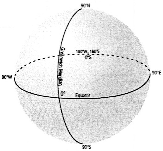
Put simply WGS84 is a system of spherical coordinates where a point on the surface of the planet is measured in degrees east or west from the Greenwich Meridian and north or south from the equator. This method is nothing new, and the concept may well be familiar to anyone who remembers any school geography, bur what happened in 1984 is that a series of rules were established that took into consideration such things as the uneven shape of the planet, the arbitrary nature of the Greenwich Meridian and constantly changing magnetic north, in ways that huge advances in number computer technology now made practical.
Wait a minute or walk a minuteA full circle comprises 360° (degrees) and, on our three dimensional globe, we measure points between 180° east and 180° west of Greenwich and from 90° north (the North Pole) to 90° south (the South Pole) of the equator. The reasoning behind using a full 360° east-west but only 180° north-south is somewhat arbitrarily based on the axis of the globe - the equator runs all the way round the girth of the globe (360°) but the Greenwich Meridian only runs 180° (from the North Pole to the South Pole) down one side of the planet. This range gives us full coverage of the globe. We only need to go 'up' or 'down' 90° because moving a full 180° either east or west allows us to see around the 'back' of the globe. We should use a full 180° north-south, but that would give us two ways of describing any point. A point 0° east and 89° north would be a point just 'under' the North Pole and could also be described as 180° east, 91° north.
Moving 1° north from the equator is the equivalent to walking 1.8km, so any 'polar' coordinate system clearly needs to be able to specify a point to within very small fractions of a degree. Traditionally, 1 degree was split up into 60 'minutes' (') and then each minute into 60 seconds (“). And if you wanted more accuracy than a second you might use a decimal fraction (e.g. 0.6) of a second. But this is somewhat anomalous in the digital, metric age so it is marginally more common to simply divide each degree into decimal fractions. For instance l.25° = 1° 15' or 28.5° = 28"30' or 54.2784722222° = 54°16'42½". I say marginally because, whilst decimal degrees are easier to do calculations with (and easier to enter into a navigation device), human beings, particularly more traditional ones, often like to think in minutes and seconds - just as some prefer yards to metres. It is also not uncommon to see degrees, minutes and then a decimal division of the minutes, e.g. 26°32.6734'
|
 |
 WGS84
is the native Datum of the Global Positioning System (GPS) - or NAVSTAR
as it is formally known in military circles. It is the common language
for navigating the Earth. The clever part of the GPS is the electronic
communications technology that allows someone to stand outdoors in
almost any part of the world with nothing more than a battery-powered
radio receiver, and know exactly where they are on the globe.
WGS84
is the native Datum of the Global Positioning System (GPS) - or NAVSTAR
as it is formally known in military circles. It is the common language
for navigating the Earth. The clever part of the GPS is the electronic
communications technology that allows someone to stand outdoors in
almost any part of the world with nothing more than a battery-powered
radio receiver, and know exactly where they are on the globe.
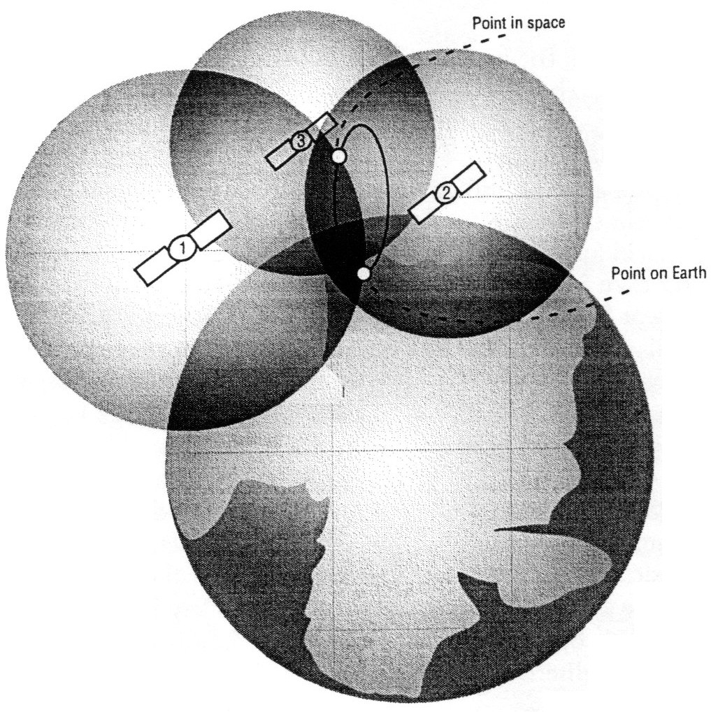
In 1978 the US Government began to launch a constellation of 24 satellites spaced around the Earth, in near circular orbit, constantly transmitting not much more than their position in the sky and the time of day (according to an atomic clock on board) back to Earth. That may seem like a pretty pointless task, but what you actually had was a series of trig points in the sky. Just as with land-based trig points, if you can measure your distance from three or more of them, you can plot your position precisely. Because these trig points are up in the sky, a large area on the Earth has a direct line-of-sight to each trig point, so you only need 24 or so to cover the entire planet. Contrast that with the 6,000 trig points on the bumpy surface of the UK, once used for land-based surveying.
These GPS satellites are monitored, controlled and adjusted from five ground stations. Each satellite repeatedly transmits the time, ephemeris data on its exact position (they deviate slightly from the theoretical position) every 30 seconds (valid for 30 minutes), and almanac data on the approximate positions of all satellites in the constellation (valid for a month or so). The US Government developed corresponding GPS receivers - electronic radio receivers with small satellite dishes - to pick up the signals being broadcast from the satellites. When the receiver could 'see' the signal from three or more of the satellites, it would download and decode the full almanac and ephemeris data from each and by comparing the time delays in the signals from each, it could work out the relative distance between the satellites and the receiver and use the rest of the almanac data to calculate the exact position of the receiver on the planet. This is known as obtaining a fix.
Strictly speaking, because the clock on the GPS receiver is not as accurate as the atomic clocks on the satellites, you need a fourth satellite to determine the inaccuracy, but using only three satellites (two for position one for accuracy), gives two possible positions, one of which is usually complete nonsense (such as a point in space). However if a fourth satellite is available, it is possible to calculate altitude too (a so-called 3D fix as opposed to a 2D fix). Crucially, the receivers worked anywhere in the world (outdoors) - even in hostile territories. The US Army could drop a battalion somewhere on the planet and allow them to find and make a safe camp. Using a GPS receiver, the battalion could then communicate their exact position back to base.
This system gave the US a vast strategic advantage in combat and peacekeeping - provided, of course, the system was a secret. The trouble was, the concept was so simple it didn't take long for others to work out how GPS worked and exploit the signals being transmitted from the satellites. The US Government acknowledged this and realised even if it encrypted the signals, other nations could easily launch their own constellations and establish their own GPS network. It also realised the data would be hugely useful commercially, socially and for air and marine safety. Following a navigation-related air disaster in 1983, the US Government freely allowed independent development of GPS receivers. It knew advancing technology would soon lead to very accurate handheld receivers, operated by battery and with very small, hand-held antennae. It also believed commercial and social applications would not call for accuracy to within a few metres, so decided to introduce an intentional 'error' into the system. This system of 'Selective Availability' (SA) allowed the US Government to compensate for the intentional error and maintain relatively accurate readings (to within 7 metres or so) whilst everyone else obtained a less accurate reading (to about 100m or so). But SA proved relatively easy to circumvent - by the use of calibrated ground stations or using two GPS receivers a known distance apart, to calculate and eliminate the error. In May 2000, the US Government turned off Selective Availability, and commercial GPS receivers became ten times more accurate, literally overnight. SA had been turned off before - for a period during the Gulf War when the US military had to use commercial GPS receivers because supply of military-grade units was limited.
With selective availability turned off, the accuracy of any receiver depends upon a number of factors, including the quality of the receiver, its ability to perform calculations on small numbers, its accuracy in timing, errors in the data from the satellites and in their orbits, the relative positions of the satellites in view, atmospheric conditions and surrounding geology and buildings. The errors present in the satellite constellation can be calculated and reduced, and the most common method is Differential GPS, which uses ground stations or other fixed GPS receivers to calculate any error. This can increase the accuracy of a handheld GPS receiver to two or three metres when moving (less when stationary). Without it, a modern handheld receiver can be expected to be accurate to within 7 metres or so, with 95% certainty.
 The
first recreational GPS receivers were aimed at recreational sailors and
pilots, and had price tags to suit those expensive activities, but
within the last few years, prices have fallen - several basic handheld
units are available for less than £100. Whilst many of the features of
the recreational units are still aimed at marine and aeronautical users,
manufacturers do now recognize the activities of walkers, hikers and car
drivers when introducing new models.
The
first recreational GPS receivers were aimed at recreational sailors and
pilots, and had price tags to suit those expensive activities, but
within the last few years, prices have fallen - several basic handheld
units are available for less than £100. Whilst many of the features of
the recreational units are still aimed at marine and aeronautical users,
manufacturers do now recognize the activities of walkers, hikers and car
drivers when introducing new models.
At its most basic, a GPS receiver
will, after switching on and acquiring full ephemeris and almanac data
(obtaining a fix), display the current location according to the WGS84
Datum. How long it takes to do that will depend on the surrounding
geology and architecture, and the quality of the radio receiver in the
GPS unit. And this is the first place we start to see differences
between models. Once a GPS has complete data from three (2D fix) or more
(3D fix) satellites and has a full set of data, it will, in general,
recover from any short breaks in satellite coverage as the receiver is
moved through its surrounding, within seconds as it already has the
ephemeris and almanac data in memory. But again, the quality of the
receiver will dictate its ability to cope in areas of poor reception. It
is worth pointing out that satellite signals are very weak and even the
best handheld unit would be unable to get a fix inside a building or in
a heavily wooded area.
Beyond issues of reception, the first feature you might want to be sure of, is the ability to display coordinates according to the OSGB36 datum instead of WGS84, and also the ability to display coordinates in Ordnance Survey Landranger Grid format (e.g. TR 16789 67544) rather than in decimal degrees. Note that these are two different features. The grid setting or coordinate format is a display issue, akin to the difference between miles and kilometres, whereas the Datum setting is more complex and determines how the receiver interprets the shape of the globe. Landranger maps do show the latitude and longitude in degrees and minutes, but they are plotted to the OSGB36 datum (confused yet?), so in theory the Datum issue is more crucial than the coordinate format. Basically, you need to ensure your GPS talks the same language as your maps. If you are using Landranger look for OSGB36, but if you only ever use Imray marine charts of the Mediterranean, look for support for the European 1950 Datum. Geocaching (see Clive's article overleaf) uses the WGS84 Datum and metric degrees, so any GPS receiver will do the trick.
It is important to stress two things that a typical GPS receiver is not. Firstly it is not a compass. If you are standing still in the middle of a field and to start to rotate the device around a fixed point, it won't tell you what direction it is facing. What it will do, however, is tell you in what direction you are moving. Because accuracy of the receiver is limited to a few metres, simply moving about from foot to foot in a confined space will give you no accurate indication of which direction you are facing or how fast you are jiggling about. If you really want to know what direction you are facing walk forward in a straight line for ten or fifteen paces and the GPS will tell you what direction you just walked in. This isn't a practical limitation, because if you do set off in the wrong direction, the receiver will soon tell you how to correct it. There are advanced units that contain electronic compasses, but they are intended for vehicle use.
 Secondly
a GPS receiver is not a mapping device. Many new owners are disappointed
that when they first obtain a fix, a wonderful illustration of the
surrounding walkways and features does not appear on the display. GPS
receivers are primarily intended to be used with some external map
(which might be electronic - more on that later) and holding detailed
maps of the world inside a small handheld device is not cost-effective.
Many GPS receivers do have primitive databases of, say, major cities,
but that is really only of passing interest to an airline passenger or
motorway driver and of virtually no use to the typical walker! However
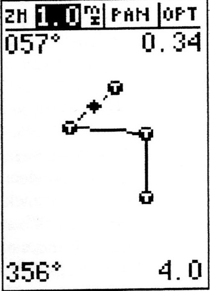
GPS receivers do normally allow the user to store and plot a series of
waypoints. These are locations that you have visited and marked on the
receiver when you were physically at the location, or have keyed in full
coordinates for separately - perhaps you read them off a map or were
given them as part of a puzzle. With these keyed in, the receiver will
show your position relative to those waypoints, which can be helpful for
navigating between them. Additionally the receiver may be able to keep a
track in its memory - that is to say, plot a line showing the route you
travelled, allowing you to retrace your steps, for instance. Before
setting off on a journey you might program a route into your GPS
receiver comprising of a number of key points read from a map, such as
Secondly
a GPS receiver is not a mapping device. Many new owners are disappointed
that when they first obtain a fix, a wonderful illustration of the
surrounding walkways and features does not appear on the display. GPS
receivers are primarily intended to be used with some external map
(which might be electronic - more on that later) and holding detailed
maps of the world inside a small handheld device is not cost-effective.
Many GPS receivers do have primitive databases of, say, major cities,
but that is really only of passing interest to an airline passenger or
motorway driver and of virtually no use to the typical walker! However
GPS receivers do normally allow the user to store and plot a series of
waypoints. These are locations that you have visited and marked on the
receiver when you were physically at the location, or have keyed in full
coordinates for separately - perhaps you read them off a map or were
given them as part of a puzzle. With these keyed in, the receiver will
show your position relative to those waypoints, which can be helpful for
navigating between them. Additionally the receiver may be able to keep a
track in its memory - that is to say, plot a line showing the route you
travelled, allowing you to retrace your steps, for instance. Before
setting off on a journey you might program a route into your GPS
receiver comprising of a number of key points read from a map, such as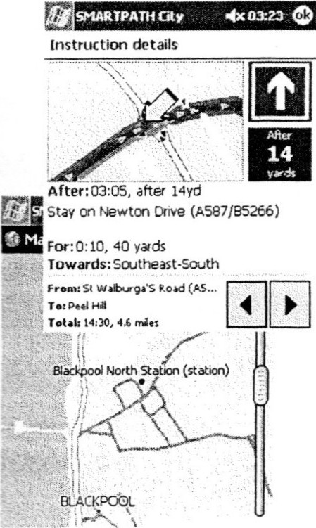 large features, turning points, your destination, hazards, etc. When you
are at your start point, you will then be able to see those points on
the screen of the receiver and by telling it what order you want to
visit those points, the receiver will guide you to those points with
helpful direction and distance indications. Remember to key in any
waypoints with the receiver set to the same datum and coordinate system
as the source of your waypoints!
large features, turning points, your destination, hazards, etc. When you
are at your start point, you will then be able to see those points on
the screen of the receiver and by telling it what order you want to
visit those points, the receiver will guide you to those points with
helpful direction and distance indications. Remember to key in any
waypoints with the receiver set to the same datum and coordinate system
as the source of your waypoints!
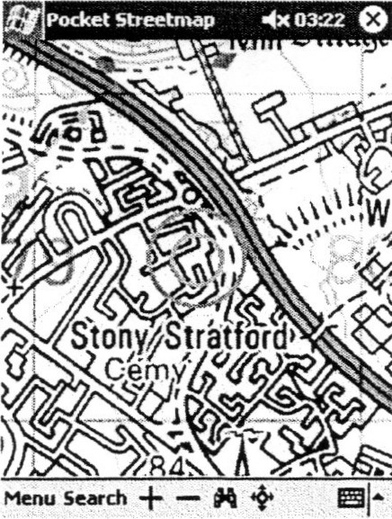
That said, there is a growing market
for GPS receivers with maps and these come in two flavours - a dedicated
handheld unit usually with a basic black and white map display, or a
handheld/portable computer connected to either an internal or external
GPS receiver. The dedicated units are the less expensive option and are
very convenient - though they can still be twice the price of a unit
without a map facility. Neither type of unit can be expected to hold
maps of the entire globe so they rely on maps of a specific area being
downloaded into the unit - often using a PC and CD- ROM - before the
journey commences. Typically the maps will be supplied with the unit or
may be bought separately. Certain models may have a limited
selection
of maps available and they may be of a specific type (e.g.
aeronautical). Additionally maps need updating over time, so when
investing in such a system, choose carefully and think ahead. The
GPS/computer combinations tend to more flexible in this regard, and
there is software available that
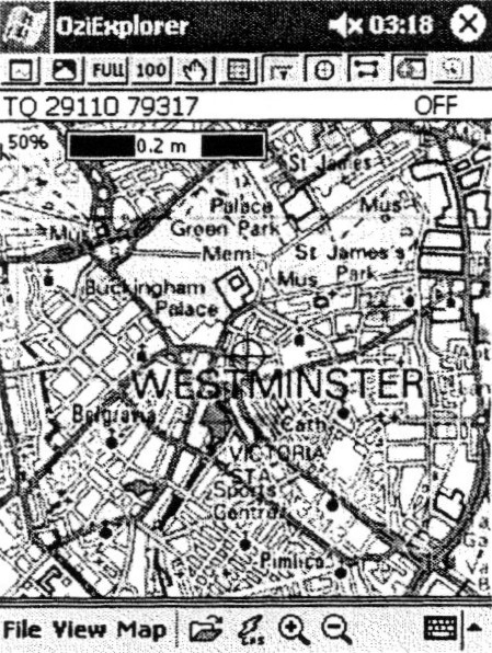
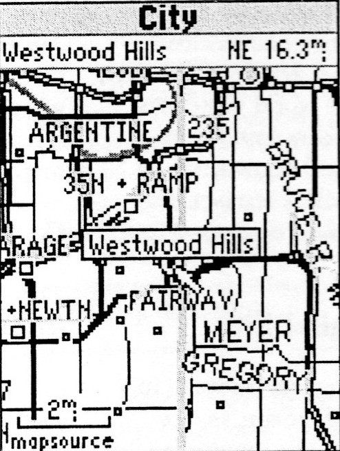 allows paper maps to be scanned in and
calibrated for use with the GPS. Many electronic maps have the added
ability of being able to provide route-planning and direction-giving
features and such systems are now commonplace at the top end of the car
market. Typically such systems give a very angular, electronic
representation of roads, etc, which are often not particularly suitable
for walkers or cyclists who like to see more accurate representations of
geological and architectural features, as found on a paper map.
allows paper maps to be scanned in and
calibrated for use with the GPS. Many electronic maps have the added
ability of being able to provide route-planning and direction-giving
features and such systems are now commonplace at the top end of the car
market. Typically such systems give a very angular, electronic
representation of roads, etc, which are often not particularly suitable
for walkers or cyclists who like to see more accurate representations of
geological and architectural features, as found on a paper map.
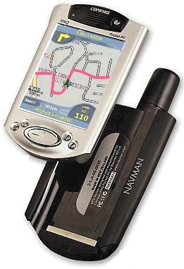
There is a middle ground. If you have a desktop PC or Mac at home, and a simple non-mapping GPS receiver, it is often possible to use mapping software on the PC to plot routes and waypoints and download them to the handheld receiver using a special cable. Software is freely available for the more popular brands of receiver (Garmin, Magellan, Lowrance, Eagle. etc) to facilitate such downloads.
Although mapping is a growth area don't feel that such a facility is essential, especially for walking activities. The ability to simply read off coordinates and find them on a paper map will be quite sufficient for most purposes. And Geocaching needs no such nonsense whatsoever!
The author of this article can frequently be found wandering around with a small, handheld colour computer with GPS receiver attached, and a variety of mapping software.
There are so many different models and so many different options it can be hard to know what to go for. Unfortunately there aren't a large number of high street outlets for GPS receivers, which tend to be hidden in the back of outdoor pursuit retailers (such as Field & Trek or YHA) or buried in the catalogues of electronics retailers (such as Maplin). Finding a knowledgeable sales assistant can be something of an impossible task too! That said, being able to see the devices and turn them on gives you a much better feel for usability than buying from catalogues or online. If you have never seen a GPS receiver before, try and find a retailer who will show you a few models - so you know what to expect. Then search around on the Internet or in catalogues to see a wider range of models and prices.
Most importantly, when you have bought a receiver, go outside with a map, sit on a park bench and familiarize yourself completely with its features. After that, you need never be lost again.
joe.mehaffey.com Joe Mehaffey and Jack Yeazel's GPS Information - The first place to go. For new and experienced users alike, this site has everything you need to know plus an awful lot you don't.
 http://www.garmin.com/ Garmin
http://www.magellangps.com/ Magellan - along with Garmin, probably the two best known GPS manufacturers
http://www.eaglegps.com/ Eagle
http://www.lowrance.com/ Lowrance
http://www.navman-mobile.co.uk/ Navman GPS receiver cards for PCs and PocketPCs and Palm
www.microsoft.com/uk/homepc/autoroute Europe-wide route planning software with basic GPS abilities to display the current location.
pocketstreetmap.com A PocketPC version of the popular UK internet mapping site Streetmap
www.ozieexplorer.com PC and PocketPC software for scanning, calibrating and using paper maps with a GPS.